Our Arctic cruise took us from Hamburg to the High Arctic! We reached Svalbard (Longyearbyen, Barentsburg) and saw the polar bear warning signs. We also visited Tromsø (midnight sun), hiked Molde, saw the stunning Geirangerfjord at 5 AM, and navigated life aboard the MSC Preziosa.
Hello from Helsinki, Finland.
This is a quick update on our cruise aboard the MSC Preziosa: we sailed from Hamburg up the Norwegian coast to Svalbard, then back down to Norway and returned to Hamburg—flying to Helsinki the same day we docked.
Hamburg in 24 Hours
We booked a hotel/hostel we thought was near the cruise terminal (it wasn’t), grabbed a 24-hour transit pass, and joined a free walking tour. Key tidbits: Hamburg is very wealthy (think many millionaires and a few billionaires), the swans are protected (they even get heated ponds in winter), and the Hanseatic League left a big legacy. Our day pass saved us when we discovered the actual cruise terminal.
Life Aboard MSC Preziosa
We were in the minority language-wise; most guests were German or Italian. Every announcement came in five languages (English, German, Italian, Spanish, French)—impressive and… long.
- Smoke zones: Abundant, often occupying prime deck space—tough for us.
- Water policy: No tap water in the restaurant; bottled only (2–3€) felt at odds with the sustainability messaging.
- Food: Solidly mediocre.
Port 1 — Molde (62°45′23″N 07°14′19″E)
Approaching/leaving via the fjords was half the magic. In town we hiked up to Varden (407 m) for sweeping views (and a quick geocache). We didn’t have time for the famed Atlantic Road drive.
Night Rescue at Sea
En route to Tromsø around 11 pm, a medical evacuation unfolded: the ship reversed to meet a helicopter; crew were lowered, and the patient was winched up in a basket. Surreal to watch from deck.
Port 2 — Tromsø (69°40′58″N 18°56′34″E)
We walked to the Arctic–Alpine Botanical Garden (impressive at this latitude) beside the university (Aurora College has partnered with UIT before—fun connection). The city buzzed with midnight-sun festivities and a marathon. We crossed to the Arctic Cathedral and started up toward Fløya—skipped the pricey funicular and, after 16 km already on foot (with 7 km back to the ship), called it wisely short of the summit.
Port 3 — Svalbard: Longyearbyen & Barentsburg
Longyearbyen (78°13′N 15°38′E) greeted us with dog teams and the famous polar-bear warning sign—the informal “no-go” line without a rifle-carrying guide. We nabbed our most northerly geocache and hustled back for our noon tour.
Barentsburg (78°04′N 14°13′E) is the last active Russian coal town in Svalbard. A fast boat (no commentary) whisked us over; a young Russian guide toured us for ~45 minutes and we spent the rest swapping stories with our new Finnish friend, Veera, in the Red Bear bar. Workers (mostly Ukrainian) sign two-year contracts and can’t leave the settlement; supplies arrive every two months. The mix of fresh paint and Soviet-era wear tells its own story.
Back in Longyearbyen (it was Sunday), almost everything had closed by 4 pm—except the museum and the “world’s northernmost” brewery. Nice beer, northern prices.
Bonus — Pyramiden from the Wake
Departing Svalbard, the captain detoured into the fjord past Pyramiden, an abandoned Russian mining town (seasonal hotel only). This was our trip’s highest latitude—and the most northerly I’ve ever been (beating my Igloolik, NU record).
Port 4 — Honningsvåg & the “Real” North Cape (70°58′43″N 25°58′36″E)
Most folks bus to Nordkapp (marketed as Europe’s northernmost point), but Svalbard beats it, and there’s a nearby point that’s actually farther north. We split a van with a Swiss family, aimed for the two-hour hike to the real cape, and turned back when pea-soup fog rolled in. Plan B: loop the island—quiet fishing villages, lookout pulls, and lots of reindeer. Back in town, we grabbed an easy geocache near the pier, ate on board, then popped out again for a late wander (sailing at ~2 am).
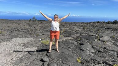
Port 5 — Geiranger (62°05′58″N 07°12′23″E)
The star here is the Geirangerfjord itself: we were on deck by 5 am for the sail-in, then again for the sail-out. In port, we followed a tip from the TI and hiked to a viewpoint that—somehow—no one else had to themselves. New favorite profile photos were born.
Port 6 — Stavanger (58°57′48″N 05°43′08″E)
Norway’s oil capital (third-largest city) tempted us with Preikestolen (Pulpit Rock), but the ship’s window was too tight and excursions too pricey. We roamed instead: swans squabbling, bright lanes, and cobbles in Old Town. One day we’ll be back for Pulpit Rock, Kjerag, and Trolltunga.
Sea Days, Small Rituals
We fell into a pleasant pattern: trivia on sea days (same friendly faces), a couple of shows (acrobatics were best), and dinners with the only other Canadians we met. Our waiters took great care of us.
What’s Next
We’re in Helsinki now, and tomorrow we’re off for 71 hours and 59 minutes in St. Petersburg—visa-free. Nic has tickets to two ballets; we’ll explore the city and the Hermitage, then return to Tallinn on July 8 (birthday bonus!). Next post: Helsinki & St. Petersburg.